

Rail to Trail - Ash to Wanborough

Step by step guidance
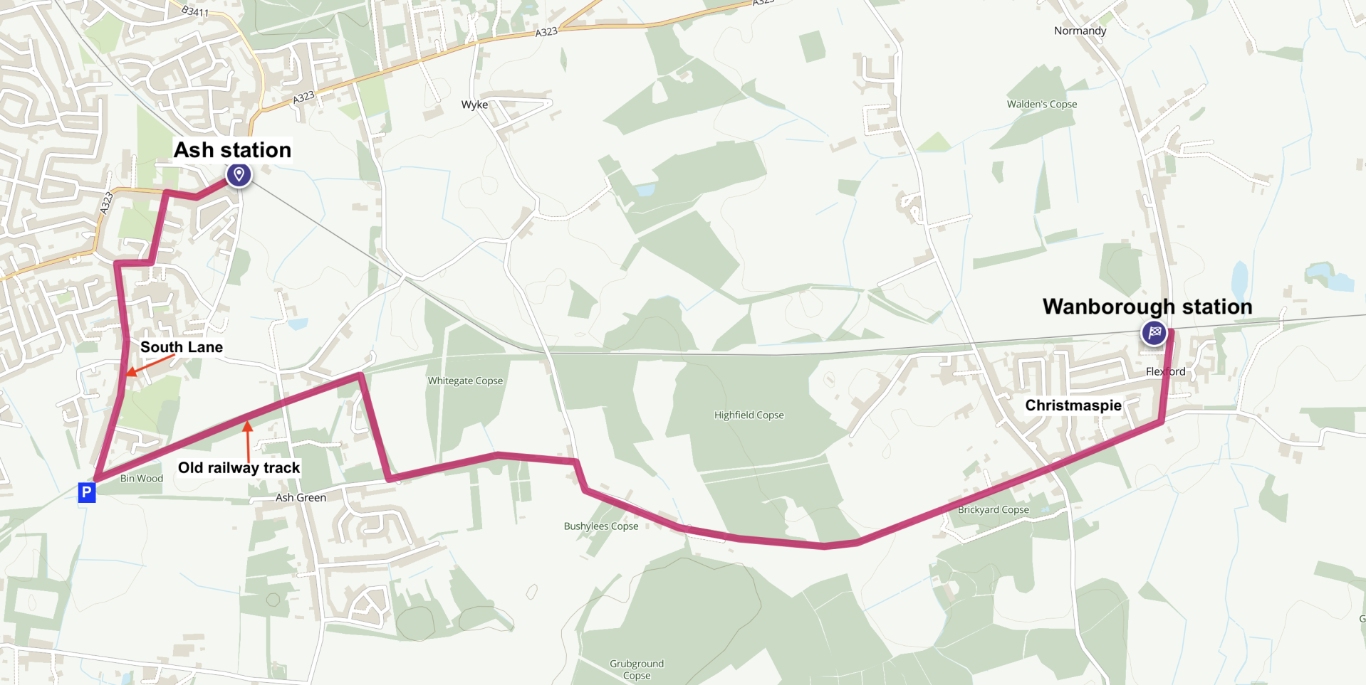
From the Car Park - 3.7 miles
This is at the very bottom end of South Lane. GU12 6GH or What3words ///best.wiser.drape or OS Map Ref. SU895498. Join the rough path at the end of the car park, turn right and immediately left to the second wider track under the pylons and turn left. This old railway line is now a footpath.
Over to your right is Bin wood, Part of the Ash Green Meadows SANG. This wood has many young ash trees and in spring bluebells and pignut. Pignuts are so called because the rout is in a form similar to a chestnut and it is edible. This is also a place to find black briony a very common poisonous plant with beautiful red berries in late summer. Continue under the bridge passing the cottage on the left. Enjoy the varied hedgerows with blackthorn, hawthorn and hazel amongst other trees. Just before the next brick bridge you’ll see a path turning off to the left take this up the few steps and turn right onto the lane. Follow this lane around to the right over the bridge. Continue straight on. After less than 100 yards leave the roadways and continue straight on into the woods. This is a bridle path often used by horses. The bridle path and footpaths separate here and there and you can take either, often the footpath will be easier walking especially after rain. You will emerge at Ash Green Lane East and a vehicle scrapyard, turn left and leave it well behind you. This lane is largely traffic free with few vehicles. It suffers here and there from some fly tipping, however it makes a very pleasant shaded walk with plenty of birds singing alongside and some interesting fields. I spotted a sparrowhawk circling overhead. In September some of the land to the north or the left of the lane is full of fleabane, hairy willowherb and some marsh thistle and many blackthorn i.e. sloe bushes. This looks a good area for butterflies and birds in spring. Birds here in late summer include blackbirds, robins, wrens and goldfinch. I enjoyed a feast of blackberries here. Continuing on the lane to the end pass a small duck pond and join the quiet tarmac lane to the right, continuing until the tarmac runs out. You may find a few places along here where food items such as eggs and vegetables are left out with an honesty box. Although the lane becomes a rough track it is still very easy to walk with plenty of tall trees and a few buildings on one side. Keep going in a straight line and the lane will soon again become tarmac with a few houses.
At the main road cross straight over and join the roadside footpath. This is the oddly named village of Christmaspie. Follow the main road past a couple of junctions then around to the left and the station is a short way on your left hand side.
Optional walk extension - increase walk to 4.7 miles
NOTE: If you still have lots of energy or a long wait for a train, instead of turning left here continue straight on, cross the little bridge over the stream and take the first turning left. The lane bends to the right and a short way along on the left see some old wooden gates and a field beyond. Leave the lane, go towards the gate and turn left at the fence then right and you are on a footpath with a stream on your left. The path bends left and then around to the right with an impressive metal style to cross the railway line to another metal stile on the other side. Keep going staying on the right hand side of the field that often has horses grazing and many jackdaws in the big trees. Exit the field via a roughly constructed stile and continue. Ignore the first gates you see. After counting a couple of fields on your left you should see a footpath sign on a ground post immediately before a line of pollarded black poplar trees. If you reach a lane you have gone about 20 feet too far. Turn left here along this narrow path until you reach the road. (Although this is part of the Fox Way, a long distance footpath, it’s quite poorly maintained. Join me in mentioning this to Surrey County Council Highways.) On reaching the road turn left and follow the road to Wanborough station which is now on your right.
When you leave the train at Ash continue as below.
From Ash station
Turn right on the main road and when you reach the church follow the path sign on the left. This becomes a tarmac access road for many houses. Continue to the road junction turn right and at the next junction Give Way sign turn left into South Lane. Follow the lane all the way in a straight line to the car park at the end.

A delightful walk along an old railway line and wide green byways - 3.7 miles or optional extension to 4.7 miles
Start from Ash station or, if travelling by car from the free car park at the very bottom of South Lane (plenty of parking in the lane). The step by step guidance below includes both starting points and an optional walk extension.
Trains are generally half hourly, hourly on Sundays. Single fare Sept 2022 £2.90 (£1.90 with Railcard).
3.7 mile route

4.7 mile extended route
GPX map files
Step by step file (includes extension)

Pollarded black poplar trees

Black bryony berries

Pignut, a member of the wild carrot family

Wanborough station

Male blackbird by Dave Rimes