

Gomshall, Chilworth and Guildford Rail to Trail walks
Two great walks or one!
I have divided this walk into two parts. I did them separately and then together. The beauty of this is the choice of public transport, both bus or train serve the three stations, albeit not very frequently!
Basic info
Gomshall to Chilworth is a whisker over 5 miles with no big hills but a few shorter ones to test your lungs! The leg from Chilworth to Guildford has one fairly long climb and a couple of slopes but nothing to trouble anyone of average fitness. Neither walk has serious obstacles. No stiles. Both walks are moderate. Download the Step by Step file below.

Transport
Great Western Trains run between the three stations every 1 or 2 hours depending on the time of day but not frequently. Bus 32 (Compass Travel) from Guildford to Dorking runs mainly hourly weekdays and Saturdays and 2 hourly on Sundays.
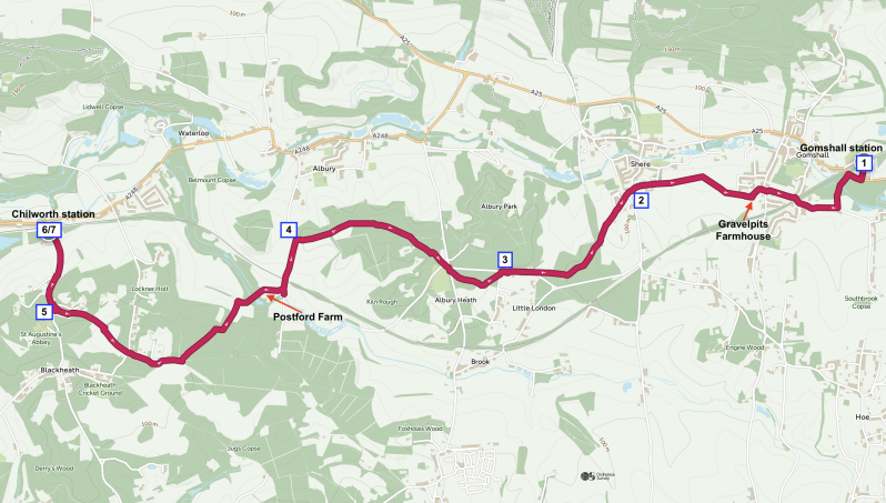
Maps
Below are maps you can print and downloadable .gpx files designed for use with the OSMaps App, see https://explore.osmaps.com/ a valuable addition to your smartphone.
Walking in the Surrey Hills always gives me a lot of pleasure. Between Gomshall and Chilworth the walk is lovely mixed countryside, woodland and heath. From Chilworth the attractions are the Gunpowder Mills and a lot of open countryside with the final stretch along the Wey Navigation into Guildford.
- From Gomshall station Platform 1, take the footpath down to the main road, cross, turn right and take the first left into Wonersh Way. Cross a low bridge over the little river Tillingbourne. Just before the first house take the public bridleway off to the right. This turns into a wider track as you keep right. At the lane, turn right under the railway bridge and turn left along High View. At the bus stop/ book swap stall, keep to the right and cross onto Gravelpits Lane a bridleway. Keep left on the track until you reach Gravelpits farmhouse where turn right and follow this bridleway along the nice tree lined path with views across to the North Downs over to your right. You will soon see a bench and a view to Shere church. At the path crossroads go straight on your current path to the lane and continue all the way to Shere Lane. If you are already in need of refreshment, take the right-hand path down to Shere Village where there is a pub, café and shop.
- Cross straight over into Pathfields. Go up the hill and follow the lane until it becomes a footpath. At the bridleway junction, keep left and then go right. Keep right at the next junction. After a few more hundred meters through the woodland at the next junction, take the right-hand option and reach the road.
- Continue in the same direction, swapping to the path on the left-hand side. At the bus stop/book swap turn left into Heath Lane. Almost immediately, turn right onto the path. At the first junction keep right and then turn right again almost immediately just before the silver birch trees. When you reach New Road turn right and then quickly left just after the postbox. Take the bridleway between the Albury Estate sign and the house. This leads through some more nice mixed woodland. Continue straight over the track. Join another path going the same way. Cross another track. Stay on this main wide path ignoring all side routes until you reach a narrow lane.
- Turn left. After passing under a railway bridge, look for your public footpath on the right at Postford Farm. Starting as a nice tarmac lane this gradually deteriorates but keep going. There’s a nice reedy area as you cross the stream. Almost at the very top of the hill, just a few feet before the house on the left, follow the public footpath sign and turn left up the slope and through the gate. On reaching the major path junction take the second on your right up the hill. As you near the top of the hill, take the first footpath on your left along the high ground. You will reach a much wider track with open heath on your left. Keep going. Soon you will see a path sign angling right, Take this back through the trees. Stay on this ignoring a path that veers off to your left until you meet a narrow lane.
- Cross straight ahead onto Blackheath Common. The path splits but keep going in the same direction across the open heath. When I visited there were signs of fire which spread across much of the valuable heathland. This will hopefully regrow in time. Over to your left on a small hill is a memorial to the local men who died for their country in the first world war. Back to your path continue in the same direction and at the junction join the track in front of you going off right and then bending left. A narrow path appears on the left and join this going down the hill. Cross the next track still on the narrow path. I heard a Tawny Owl here at 1 pm on a winter’s day. Eventually, you reach a lane.
- Turn right. This lane will now take you to Chilworth station. For your safety, you will see a footpath appears up the bank on the right-hand side to keep you off the lane. You will now have the option of a train or a number 32 bus ride. Or continue to Guildford via step 7!
- If you wish to continue now to Guildford, pass Chilworth Station, and turn left along the main road. At the end of the blue railings of the school on the right, take the footpath signposted to the Gunpowder Mills. After crossing the stream via the wooden footbridge you will see an information sign. If you wish to explore the Gunpowder Mills fully this tells you what you might find. Now, with your back to the footbridge that you just crossed, turn left and stay on the main path. Enjoy quite a few of the old remains of the Gunpowder Mills as you walk along. The ponds down to your right often hold many duck and geese in most seasons of the year. Reach the lane.
- Turn right. Cross the bridges and where the road turns sharp right, turn left at the Chilworth Old Mill signpost and take the path up on the right-hand side. At the top, and the lane turn left and go through the gate onto the bridleway down to the field edge and follow the hedgerow. These fields will often hold bird life. When I walked through in November, there was a large flock of geese and assorted corvids. Skylarks and Meadow pipits and pied wagtails may be found at any time. After about 1 km, you reach Manor Farm and buildings so follow the same path around to your right and then left staying with the fields on your right-hand side. You will soon see Saint Mary’s Church and Shalford on your left-hand side and the hills of Guildford and then the Cathedral on your right. Follow this path until you reach the lane.
- Turn right and where the lane bends left take the footpath on the right. Keep going until you pass Chantry Lodge and meet a major path/track junction. Turn left following the North Downs Way sign. Turn left at the road junction. Cross the main road and then continue in the same direction across the field in front of you. This is still on the North Downs Way. Keep going straight until you meet the River Wey Navigation. Turn left and go up and over the footbridge then follow the steps to your left along the tow path. If you do not meet the ornate little bridge and seat after just a few yards, you are going the wrong way! After passing these continue along the tow path towards Guildford Centre. Cross the two bridges to the main road.
- Turn left. At the billboard and sign for the Yvonne Arnoud Theatre turn left and follow the path to the left of the theatre. Cross the two bridges over the canal and river and turn right. Pass the White House pub and see the sign pointing left to Guildford Station. After the George Abbott pub cross the road and go up to the top pedestrian lights, cross the road straight on and the station is just a few yards around the corner. Take the train back to Gomshall or follow the signs to the Friary Bus station and return on the 32 bus.